
A river flood warning has been issued for Franklin County as portions of the Scioto River are expected to reach flood stage Wednesday morning.
The National Weather Service issued the warning, which will go into effect at 7 p.m. Tuesday and last through 1 p.m. Wednesday. A flood watch also remains in effect, as does a flood advisory for the Olentangy River near Worthington.
The Scioto River flood warning is specifically focused on the area of the river near Frank Road.
The National Weather Service said that as of 9:45 a.m. Tuesday, the river was nearly 20 feet deep. With continued rain, including possible severe storms, forecasted to continue throughout the day Tuesday, the Scioto River is expected to reach flood stage Tuesday night.
The river’s flood stage is 24 feet. The Scioto River is expected to crest to 24.5 feet early Wednesday morning before falling back below flood stage in the late morning on Wednesday, the weather service said.
The primary areas where the river’s flooding may have an impact are outside the Columbus city limits in Franklin, Jackson, and Marion Townships in southern Franklin County.
The National Weather Service also confirmed that Route 23 (High Street) is flooded near Interstate 270 and closed.
Columbus firefighters rescue couple beneath Broad Street Bridge
The rising waters in the Scioto River are already causing some problems, including requiring the Columbus Division of Fire to rescue two people from beneath the Broad Street bridge Tuesday morning.
The couple was sleeping under the bridge around 8:45 a.m. when the water started to rise. While they were never directly in the water, the flooding prevented them from returning to the shore, Columbus Division of Fire Battalion Chief Jeff Geitter said.
A boat from the Columbus Division of Fire retrieved them and brought them to shore. No injuries were reported.
Central Ohioans should expect excessive runoff that could result in flooding of rivers, creeks, streams, and other low-lying and flood-prone locations. Each round of storms expected throughout the day carries the potential of heavy rain, the NWS said.
Anyone living within the watch area, especially in areas prone to flooding, should be prepared to take action should flooding develop.
The most severe storms are expected to reach the Columbus area between 3 p.m. and 10 p.m.
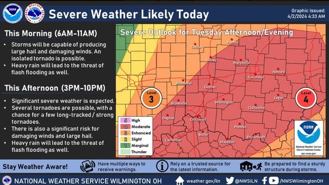
“Damaging winds, large hail, and several tornadoes, some strong or intense, will be possible,” the NWS Wilmington office warned in its updated hazardous weather advisory.
The NWS has a flood watch throughout central Ohio as heavy rains have swollen area streams and caused flooding along some roadways as well as in Whitehall park.
At 7 a.m., the NWS issued a flood advisory for the following counties in Ohio:
Adams, Auglaize, Brown, Butler, Champaign, Clark, Clermont, Clinton, Darke, Delaware, Fairfield, Fayette, Franklin, Greene, Hamilton, Hardin, Highland, Hocking, Licking, Logan, Madison, Mercer, Miami, Montgomery, Pickaway, Pike, Preble, Ross, Scioto, Shelby, Union, and Warren.
Counties included in the hazardous weather outlook include: Wayne, Fayette, Union, Hardin, Mercer, Auglaize, Darke, Shelby, Logan, Delaware, Miami, Champaign, Clark, Madison, Franklin, Licking, Preble, Montgomery, Greene, Pickaway, Fairfield, Ross and Hocking.
Flooding already beginning around Columbus, some road closures

Parts of Interstate 71 are flooded just after 9 a.m. north of Interstate 270 and Interstate 161 stopping traffic on both sides. For latest highway and road conditions, visit the Ohio Department of Transportation’s real-time map at Ohgo.com.
Reports of on Havens Corners Road east of North Waggoner Road in Jefferson Township, eastern Franklin County, a part of the county struck by an EF2 tornado in late February.
There are also reports that Sugar Run flooded at New Albany’s Taylor Farm Park along Harlem Road near East Dublin-Granville Road along the Columbus border. Market Street in New Albany at Reynoldsburg-New Albany Road is also flooded.
The NWS stressed that you should turn around if you encounter flooded roads, as most flood deaths occur in vehicles.
Are Columbus-area schools closed or delayed due to flooding?
School closures due to the flooding have been limited, but the storms impacted a handful of districts.
- Circleville isn’t transporting students
- Madison-Plains is closed
- Pickerington Local Schools main parking lot is flooded
Severe storms with potential tornadoes Tuesday afternoon and evening
Showers and thunderstorms are also possible before 10 a.m. and will include some heavy rain, the NWS said. High temperatures are expected near 73 degrees, with southeast winds between 7 mph and 17 mph becoming west in the morning. Winds could gust as high as 29 mph, and the chance of precipitation is 100%. New rainfall amounts to between a half and three quarters of an inch.

The arrival of the cold front and the warm afternoon temperatures will likely combine to produce widespread severe thunderstorms and potentially tornadoes Tuesday afternoon and evening. New rainfall amounts of between a half-inch and three-quarters of an inch or more are forecast.
Expect more showers and possible thunderstorms later Tuesday night, going into early Wednesday. There is a slight chance of showers again after 5 a.m. Wednesday, with an overnight low around 38 degrees.
The rest of the week’s forecast includes rain and possible snow, continuing through Friday.


